. Scientific Frontline: Search results for volcanoes
Showing posts sorted by relevance for query volcanoes. Sort by date Show all posts

Wednesday, November 3, 2021

1,800-plus ‘young’ volcanoes in the U.S. Southwest

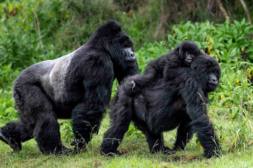
The peaks of monogenetic volcanoes,
viewed across Lunar Lake in Nevada.
Credit: Greg Valentine
They’re born. They live once, erupting for a period that might last for days, years or decades. Then, they go dark and die.

This narrative describes the life of a monogenetic volcano, a type of volcanic hazard that can pose important dangers despite an ephemeral existence.

The landscape of the southwestern U.S. is heavily scarred by past eruptions of such volcanoes, and a new study marks a step toward understanding future risks for the region.

The research, which will be published on Nov. 2 in the journal Geosphere, provides a broad overview of what we know — and don’t know — about this type of volcanism in the U.S. Southwest over the past 2.58 million years, a geologic period known as the Quaternary.

During this time, more than 1,800 monogenetic volcanoes erupted in the region, according to a count covering Nevada, Utah, Arizona, Colorado, New Mexico and parts of California’s eastern edge. Add in the Pinacate volcanic field, located mostly in the Mexican state of Sonora, bordering Arizona, and the number goes up to over 2,200, scientists say. (The volcanoes included are ones whose ages are estimated to be in the range of the Quaternary, but many have not been precisely dated.)

“Monogenetic means ‘one life,’” says lead author Greg Valentine, a University at Buffalo volcanologist. “So a monogenetic volcano will erupt once, and that eruption may last for several days to several decades, but after that, the volcano is basically dead.

“In the United States, most volcanic hazards-related attention has rightly gone to places like Hawaii, and to the Pacific Northwest and Alaska, where we have big stratovolcanoes like Mount Rainier and Mount St. Helens, which will have many eruptive episodes over a long life, with widespread hazardous effects. In the past, these smaller monogenetic volcanoes really haven’t been looked at from a focus on hazards; they have been instead studied mainly for what they tell us about the deep earth. Recently, however, there has been more buzz in the research community about how we need to take a look at the kinds of hazards these volcanoes might pose.

Thursday, May 19, 2022

Astronauts may one day drink water from ancient moon volcanoes

Scientists believe that the moon's snakelike
Schroeter's Valley was created by lava flowing over the surface.
Credit: NASA Johnson
Billions of years ago, a series of volcanic eruptions broke loose on the moon, blanketing hundreds of thousands of square miles of the orb’s surface in hot lava. Over the eons, that lava created the dark blotches, or maria, that give the face of the moon its familiar appearance today.

New research from CU Boulder suggests that volcanoes may have left another lasting impact on the lunar surface: sheets of ice that dot the moon’s poles and, in some places, could measure dozens or even hundreds of feet thick.

“We envision it as a frost on the moon that built up over time,” said Andrew Wilcoski, lead author of the new study and a graduate student in the Department of Astrophysical and Planetary Sciences (APS) and the Laboratory for Atmospheric and Space Physics (LASP) at CU Boulder.

He and his colleagues published their findings this month in The Planetary Science Journal.

The researchers drew on computer simulations, or models, to try to recreate conditions on the moon long before complex life arose on Earth. They discovered that ancient moon volcanoes spewed huge amounts of water vapor, which then settled onto the surface—forming stores of ice that may still be hiding in lunar craters. If any humans had been alive at the time, they may even have seen a sliver of that frost near the border between day and night on the moon's surface.

It’s a potential bounty for future moon explorers who will need water to drink and process into rocket fuel, said study co-author Paul Hayne.

“It’s possible that 5 or 10 meters below the surface, you have big sheets of ice,” said Hayne, assistant professor in APS and LASP.

Wednesday, May 17, 2023

Are Earth and Venus the only volcanic planets? Not anymore.

LP 791-18 d is an Earth-size world about 90 light-years away. The gravitational tug from a more massive planet in the system, shown as a blue disk in the background, may result in internal heating and volcanic eruptions – as much as Jupiter’s moon Io, the most geologically active body in the solar system.
Illustration Credit: NASA’s Goddard Space Flight Center/Chris Smith/KRBwyle

Scientific Frontline: "At a Glance" Summary

  • Main Discovery: The identification of LP 791-18 d, an Earth-sized exoplanet orbiting a red dwarf star 90 light-years away, which is likely covered in active volcanoes due to intense gravitational heating.
  • Methodology: Researchers utilized photometric data from NASA’s Transiting Exoplanet Survey Satellite (TESS) and the retired Spitzer Space Telescope to detect the planet and analyze its orbit, specifically measuring transit timing variations caused by the gravitational tug of a larger neighboring planet, LP 791-18 c.
  • Key Data: LP 791-18 d has a radius and mass consistent with Earth (approximately 1.03 Earth radii and 0.9 Earth masses) and orbits its host star every 2.8 days; its massive neighbor passes as close as 1.5 million kilometers, generating sufficient tidal friction to fuel volcanic activity comparable to Jupiter’s moon Io.
  • Significance: This finding provides a rare analog for studying the long-term evolution of terrestrial planets and how extensive volcanic outgassing can sustain an atmosphere on tidally locked worlds, potentially allowing water to condense on the planet's dark side.
  • Future Application: The planet serves as a prime target for the James Webb Space Telescope (JWST) to conduct atmospheric spectroscopy, aiming to detect potential biosignatures or volcanic gases like sulfur dioxide.
  • Branch of Science: Exoplanetary Astronomy, Planetary Science.
  • Additional Detail: The planet is tidally locked, meaning one side faces the star permanently, but the suspected global volcanic activity could transport heat and maintain an atmosphere across the night side.

Tuesday, May 10, 2022

Ice-capped volcanoes slower to erupt, study finds

Undergraduate researcher Lilian Lucas, left, and geology professor Patricia Gregg found that additional pressure from thick overlying glacial ice can make volcanic systems more stable and slower to erupt than volcanoes without ice. 
Photo by Fred Zwicky

The Westdahl Peak volcano in Alaska last erupted in 1992, and continued expansion hints at another eruption soon. Experts previously forecasted the next blast to occur by 2010, but the volcano – located under about 1 kilometer of glacial ice – has yet to erupt again. Using the Westdahl Peak volcano as inspiration, a new volcanic modeling study examined how glaciers affect the stability and short-term eruption cycles of high-latitude volcanic systems – some of which exist along major air transportation routes.

The study, led by University of Illinois Urbana-Champaign undergraduate researcher Lilian Lucas, with graduate student Jack Albright, former graduate student Yan Zhan and geology professor Patricia Gregg, used finite element numerical modeling to study the stability of the rock that surrounds volcanic systems – but with a new twist. The team accounted for the additional pressure from glacial ice volcanoes when forecasting the timing of eruptions.

“Volcanic forecasting involves a lot of variables, including the depth and size of a volcano’s magma chamber, the rate at which magma fills that chamber and the strength of the rocks that contain the chamber, to name a few,” Lucas said. “Accounting for overlying pressure from polar ice caps is another critical, yet poorly understood, variable.”

Monday, November 21, 2022

Monitoring “frothy” magma gases could help evade disaster

Aerial photograph of Kusatsu-Shirane area (October 2021). Thanks to its geothermally active location, the town of Kusatsu, Gunma Prefecture (in the background of this image), is one of Japan’s most popular onsen (hot springs) destinations. The acidic and vibrant turquoise Yugama crater lake, however, is definitely not suitable for swimming.
Photo Credit: Tomoya Obase

Scientific Frontline: "At a Glance" Summary

  • Main Discovery: The ratio of Argon-40 to Helium-3 isotopes in volcanic gases serves as a precise indicator of underground magma frothiness and specific eruption risks.
  • Methodology: Researchers conducted a seven-year longitudinal study (2014–2021) collecting samples from six fumaroles at the Kusatsu-Shirane volcano, analyzing isotopic compositions via noble gas mass spectrometry and computer modeling.
  • Key Data: The study identified the specific Argon-40/Helium-3 ratio as the critical metric for measuring magma foaming, a variable derived from the seven-year dataset.
  • Significance: Monitoring magma frothiness distinguishes between eruption types; gas transfer to hydrothermal systems signals phreatic eruption risks, while increased buoyancy indicates potential magmatic eruptions.
  • Future Application: The research aims to produce portable, real-time mass spectrometers to establish continuous 24/7 early warning systems at active volcanoes.
  • Branch of Science: Volcanology and Geochemistry
  • Additional Detail: This geochemical analysis detects pre-eruptive precursors in the absence of seismic activity, providing a diagnostic capability that traditional geophysical monitoring often misses.

Thursday, February 10, 2022

A Possible COVID-19 Silver Lining for Great Ape Conservation

Mountain gorilla family
Credit: Skyler Bishop for Gorilla Doctors

Respiratory illness outbreaks among wild mountain gorillas in Volcanoes National Park have declined since the start of COVID-19, according to a “Correspondence” report in the journal Nature from Gorilla Doctors and the Rwanda Development Board.

Mountain gorillas are susceptible to human-transmitted respiratory pathogens. Respiratory illness is the second leading cause of death in wild, human-habituated populations.

In the five years prior to March 2020, the Volcanoes National Park population averaged 5.4 respiratory illness outbreaks in gorilla family groups annually. In contrast, from March 2020 through December 2021, the population averaged 1.6 respiratory illness outbreaks in the family groups each year. To date, SARS-CoV-2 has not been detected in samples collected from mountain gorillas with respiratory illness.

The decline in respiratory illness outbreaks in mountain gorillas during the COVID-19 pandemic correlates with an overall reduction in the number of people coming into close proximity of the gorillas, and with additional health protection measures taken to reduce the risk of disease transmission from humans to gorillas.

Thursday, June 15, 2023

Navigating underground with cosmic-ray muons

Navigating inside with muons. The red line in this image represents the path the “navigatee” walked, while the white line with dots shows the path recorded by MuWNS.
Illustration Credit: ©2023 Hiroyuki K.M. Tanaka

Superfast, subatomic-sized particles called muons have been used to wirelessly navigate underground in a reportedly world first. By using muon-detecting ground stations synchronized with an underground muon-detecting receiver, researchers at the University of Tokyo were able to calculate the receiver’s position in the basement of a six-story building. As GPS cannot penetrate rock or water, this new technology could be used in future search and rescue efforts, to monitor undersea volcanoes, and guide autonomous vehicles underground and underwater.

GPS, the global positioning system, is a well-established navigation tool and offers an extensive list of positive applications, from safer air travel to real-time location mapping. However, it has some limitations. GPS signals are weaker at higher latitudes and can be jammed or spoofed (where a counterfeit signal replaces an authentic one). Signals can also be reflected off surfaces like walls, interfered with by trees, and can’t pass through buildings, rock or water.

Tuesday, March 5, 2024

Can ‘Super Volcanoes’ Cool the Earth in a Major Way? A New Study Suggests No.

Quizapu Volcano, Chile
Photo Credit: Kevin Krajick / Earth Institute

Scientific Frontline: "At a Glance" Summary

  • Main Discovery: Volcanic super-eruptions likely cause significantly less global cooling than previously estimated, with temperature drops probably not exceeding 1.5°C (2.7°F) even for the most powerful events.
  • Methodology: Researchers from NASA’s Goddard Institute for Space Studies utilized advanced computer modeling to simulate climate responses to super-eruptions, specifically varying the diameter of microscopic sulfate particles injected into the stratosphere.
  • Key Data: Previous estimates suggested cooling of 2°C to 8°C (3.6°F to 14.4°F), but new simulations align more closely with the 1991 Mount Pinatubo eruption, which caused a 0.5°C (1°F) drop; a super-eruption requires releasing over 1,000 cubic kilometers of magma.
  • Significance: The findings explain the lack of archaeological or geological evidence for global-scale biological catastrophes following historical super-eruptions, such as the Toba event 74,000 years ago.
  • Future Application: The study highlights the high level of uncertainty regarding aerosol particle behavior, suggesting that intentional geoengineering via stratospheric aerosol injection remains a non-viable climate mitigation strategy for the foreseeable future.
  • Branch of Science: Earth Science, Volcanology, and Climate Modeling.
  • Additional Detail: Sulfate particles influence temperature through two counteracting mechanisms: reflecting incoming solar radiation to cause cooling and trapping outgoing thermal energy to create a greenhouse effect.

Friday, January 20, 2023

Malformed seashells, ancient sediment provide clues about Earth’s past

A drone photo of the JOIDES Resolution in the Mentelle Basin, where Northwestern scientists drilled for ancient sediment.
Photo Credit: Gabriele Tagliaro, University Sao Paulo

Nearly 100 million years ago, the Earth experienced an extreme environmental disruption that choked oxygen from the oceans and led to elevated marine extinction levels that affected the entire globe. 

Now, in a pair of complementary new studies, two Northwestern University-led teams of geoscientists report new findings on the chronology and character of events that led to this occurrence, known as Ocean Anoxic Event 2 (OAE2), which was co-discovered more than 40 years ago by late Northwestern professor Seymour Schlanger. 

By studying preserved planktonic microfossils and bulk sediment extracted from three sites around the world, the team collected direct evidence indicating that ocean acidification occurred during the earliest stages of the event, due to carbon dioxide (CO2) emissions from the eruption of massive volcanic complexes on the sea floor.

In one of the new studies, the researchers also propose a new hypothesis to explain why ocean acidification led to a strange blip of cooler temperatures (dubbed the “Plenus Cold Event”), which briefly interrupted the otherwise intensely hot greenhouse period.

Thursday, January 26, 2023

Mercury Helps to Detail Earth’s Most Massive Extinction Event

The Karoo Basin in South Africa yields clues about the largest mass extinction in earth's history
Photo Credit: Juanita Swart

Scientific Frontline: "At a Glance" Summary

  • Main Discovery: Mercury isotope signatures found in the southern hemisphere provide definitive evidence linking the Latest Permian Mass Extinction (LPME) to massive volcanic eruptions in the Siberian Traps.
  • Methodology: Researchers analyzed the isotopic composition of mercury preserved in sedimentary rock samples from the Sydney Basin in Australia and the Karoo Basin in South Africa to match chemical signatures with volcanic emissions.
  • Key Data: The event eradicated 80-90% of life on Earth; radiogenic dating and stratigraphic analysis reveal the terrestrial extinction began 200,000 to 600,000 years prior to the primary marine collapse at 251.9 million years ago.
  • Significance: The findings establish that the extinction was not an instantaneous catastrophe but a prolonged biotic crisis that originated on land due to volcanic carbon dioxide emissions and subsequent rapid warming before impacting the oceans.
  • Future Application: These historical data points serve as critical models for predicting the long-term ecological consequences of modern climate change, which mirrors the LPME's rapid injection of greenhouse gases.
  • Branch of Science: Earth Sciences (Geochemistry, Geochronology, and Sedimentology)
  • Additional Detail: This study marks the first time mercury isotope compositions from high southern latitudes have been utilized to bridge significant gaps in the global geological record regarding this extinction event.

Thursday, December 21, 2023

Gravity data could reveal underwater volcanoes with high potential for devastating eruptions

This looping video shows an umbrella cloud generated by the underwater eruption of the Hunga Tonga-Hunga Ha’apai volcano on Jan. 15, 2022. The GOES-17 satellite captured the series of images that also show crescent-shaped shock waves and lightning strikes.
Video Credit: NASA Earth Observatory image by Joshua Stevens using GOES imagery courtesy of NOAA and NESDIS

New research led by Carnegie’s Hélène Le Mével reveals new details about the system of magma chambers under the Hunga volcano, both before and after its disastrous 2022 eruption. The team’s findings, published last week in Science Advances, demonstrate a new method for probing submarine volcanoes for their potential to cause similar damage.

The eruption came at the end of a month-long period of volcanic unrest, following a seven-year hiatus for the volcano—devastating the Kingdom of Tonga islands and causing a global tsunami, an unprecedented amount of volcanic lightning, and perturbations in the upper atmosphere. . It was the largest explosive eruption recorded since Pinatubo in 1991.

“Although we have a wealth of data about the Hunga eruption’s effects both locally and globally, we know very little about its subsurface structure,” Le Mével explained.

Monday, January 17, 2022

Powerful volcanic blast not the cause for 2018 Indonesian island collapse

The dramatic collapse of Indonesia’s Anak Krakatau volcano in December 2018 resulted from long-term destabilizing processes, and was not triggered by any distinct changes in the magmatic system that could have been detected by current monitoring techniques, new research has found.

The volcano had been erupting for around six months prior to the collapse, which saw more than two-thirds of its height slide into the sea as the island halved in area. The event triggered a devastating tsunami, which inundated the coastlines of Java and Sumatra and led to the deaths of more than 400 people.

A team led by the University of Birmingham examined volcanic material from nearby islands for clues to determine whether the powerful, explosive eruption observed after the collapse had itself triggered the landslide and tsunami. Their results are published in Earth and Planetary Science Letters.

Working with researchers at the Bandung Institute of Technology, the University of Oxford and the British Geological Survey, the team looked at the physical, chemical and microtextural characteristics of the erupted material. They concluded that the large explosive eruption associated with the collapse was probably caused by the underlying magmatic system becoming destabilized as the landslide got underway.

This means the disaster was less likely to have been caused by magma forcing its way to the surface and triggering the landslide. Current volcano monitoring methods record seismic activity and other signals caused by magma rising through the volcano, but since this event was not triggered from within, it would not have been detected using these techniques.

Wednesday, September 24, 2025

Supercritical subsurface fluids open a window into the world

Interpreted 3D seismic characteristics.
The seal layer, interpreted by looking at data on the supercritical fluid’s movement, appears as a distinct region. It’s disrupted where it meets a fault which makes it appear porous to the fluid, allowing it to migrate upwards, causing seismic vibrations.
Image Credit: ©2025 Tsuji et al.
(CC BY 4.0)

Researchers including those from the University of Tokyo build on past studies and introduce new methods to explore the nature and role of subsurface fluids including water in the instances and behaviors of earthquakes and volcanoes. Their study suggests that water, even heavy rainfall, can play a role in or even trigger seismic events. This could potentially lead to better early warning systems. The study improves models of seismic activity and can even help identify optimal sites for drilling to tap sources of supercritical geothermal energy.

As far as is currently known, earthquakes and volcanic eruptions cannot be predicted, certainly not on the timescales with which we expect from typical weather reports. But as physical theories improve, so does the accuracy of statistical models which could be useful for planning, and potentially also early warning systems, which can save lives when disaster does strike. Another benefit of improving such models is that they could help locate areas suitable for tapping into geothermal energy. So, it’s the improvement of theories, based on good observations, that geologists and other researchers strive for. And a recent development in this field has added another factor into the mix which may be more significant than was previously thought.

Saturday, April 15, 2023

2022 Tongan volcanic explosion was largest natural explosion in over a century

On January 14, 2022, at approximately 4:20am local time UTC a huge eruption occurred at the Hunga Tonga-Hunga Ha’apai underwater volcano, located about 65km (40 miles) north of Tonga’s capital, Nuku’alofa, which is part of a vast arc of volcanoes and ocean trenches known as the Pacific “Ring of Fire”. 
Image Credit: © 2022 European Space Agency - ESA, produced from ESA remote sensing data, image processed by ESA. Radiometrically enhanced by the University of Miami Center for Southeastern Tropical Advanced Remote Sensing (CSTARS)

The 2022 eruption of a submarine volcano in Tonga was more powerful than the largest U.S. nuclear explosion, according to a new study led by scientists at the University of Miami Rosenstiel School of Marine, Atmospheric, and Earth Science and the Khaled bin Sultan Living Oceans Foundation.  

The 15-megaton volcanic explosion from Hunga Tonga-Hunga Ha'apai, one of the largest natural explosions in more than a century, generated a mega-tsunami with waves up to 45-meters high (148 feet) along the coast of Tonga’s Tofua Island and waves up to 17 meters (56 feet) on Tongatapu, the country’s most populated island.

Monday, October 13, 2025

Understanding volcanoes better

Oldoinyo Lengai in Tanzania is the only active carbonatite volcano on Earth.
Photo Credit: © Miriam Reiss

How do volcanoes work? What happens beneath their surface? What causes the vibrations – known as tremor – that occur when magma or gases move upward through a volcano's conduits? Professor Dr. Miriam Christina Reiss, a volcano seismologist at Johannes Gutenberg University Mainz (JGU), and her team have located such tremor signals at the Oldoinyo Lengai volcano in Tanzania. "We were not only able to detect tremor, but also to determine its exact position in three dimensions – its location and depth below the surface," said Reiss. "What was particularly striking was the diversity of different tremor signals we detected." The findings provide new insights into how magma and gas are transported within the Earth and thus improve our understanding of volcanic dynamics. This also has societal relevance as the researchers hope that their work will enhance the ability to forecast volcanic eruptions in the long term. Their results have recently been published in Communications Earth & Environment.

Sunday, February 5, 2023

Study reveals new clues about how 'Earth's thermostat' controls climate

The Amazon, Earth’s largest river, transporting weathering solutes from the Andes to the Atlantic Ocean in Brazil.
Photo Credit: Michael Vite

Rocks, rain and carbon dioxide help control Earth’s climate over thousands of years — like a thermostat — through a process called weathering. A new study led by Penn State scientists may improve our understanding of how this thermostat responds as temperatures change.

“Life has been on this planet for billions of years, so we know Earth’s temperature has remained consistent enough for there to be liquid water and to support life,” said Susan Brantley, Evan Pugh University Professor and Barnes Professor of Geosciences at Penn State. “The idea is that silicate rock weathering is this thermostat, but no one has ever really agreed on its temperature sensitivity.”

Because many factors go into weathering, it has been challenging to use results of laboratory experiments alone to create global estimates of how weathering responds to temperature changes, the scientists said.

The team combined laboratory measurements and soil analysis from 45 soil sites around the world and many watersheds to better understand weathering of the major rock types on Earth and used those findings to create a global estimate for how weathering responds to temperature.

Wednesday, March 15, 2023

Scientists have new tool to estimate how much water might be hidden beneath a planet’s surface

Exoplanets similar to Earth, artist concept.
Image Credit: NASA

Scientists from the University of Cambridge now have a way to estimate how much water a rocky planet can store in its subterranean reservoirs. It is thought that this water, which is locked into the structure of minerals deep down, might help a planet recover from its initial fiery birth.

The researchers developed a model that can predict the proportion of water-rich minerals inside a planet. These minerals act like a sponge, soaking up water which can later return to the surface and replenish oceans. Their results could help us understand how planets can become habitable following intense heat and radiation during their early years.

Planets orbiting M-type red dwarf stars — the most common star in the galaxy — are thought to be one of the best places to look for alien life. But these stars have particularly tempestuous adolescent years — releasing intense bursts of radiation that blast nearby planets and bake off their surface water.

Thursday, May 19, 2022

Scientists 'see' puzzling features deep in Earth’s interior

Etna Volcano Eruption January 12th 2011
Credit: gnuckx

Scientific Frontline: "At a Glance" Summary
  • Main Discovery: Researchers produced the first detailed, kilometer-scale image of an ultra-low velocity zone beneath Hawaii, revealing complex internal variability within the rock pocket at the core-mantle boundary.
  • Methodology: The team utilized advanced numerical modeling and high-performance computing to simulate elastodynamic wave symmetries, improving the resolution of seismic wave analysis by an order of magnitude.
  • Key Data: Seismic waves passing through the zone exhibited a 40% reduction in velocity, indicating the presence of dense, iron-rich material situated roughly 3,000 kilometers deep.
  • Significance: This evidence links deep-mantle chemical heterogeneity to surface hotspot volcanism and suggests the material may be ancient Earth remnants or iron leakage from the core.
  • Future Application: These high-resolution imaging techniques will be extended to map other core-mantle boundary zones, aiding in the reconstruction of Earth’s deep geological history and dynamics.
  • Branch of Science: Geophysics and Seismology

Sunday, May 8, 2022

Some Volcanoes Might Warm Climate, Destroy Ozone Layer


A new NASA climate simulation suggests that extremely large volcanic eruptions called “flood basalt eruptions” might significantly warm Earth’s climate and devastate the ozone layer that shields life from the Sun’s ultraviolet radiation.

The result contradicts previous studies indicating these volcanoes cool the climate. It also suggests that while extensive flood-basalt eruptions on Mars and Venus may have helped warm their climates, they could have doomed the long-term habitability of these worlds by contributing to water loss.

Source/Credit:
Video: NASA/Goddard Space Flight Center
Final Editing and Conversion: Scientific Frontline
Additional credits are embedded 

en050822_01

Saturday, January 24, 2026

What Is: Supervolcanoes

Yellowstone Supervolcano undergoing a catastrophic super-eruption.
Image Credit: Scientific Frontline / stock image

Scientific Frontline: "At a Glance" Summary

  • Main Discovery: Supervolcanoes are distinct thermodynamic entities defined by the explosive ejection of over 1,000 cubic kilometers of bulk deposits (VEI 8) and the subsequent formation of massive calderas through crustal collapse rather than edifice construction.
  • Methodology: Identification relies on high-altitude satellite imagery to spot elliptical boundaries and the anisotropy of magnetic susceptibility (AMS) to reconstruct ancient flow directions, while modern monitoring utilizes GPS geodesy and seismic arrays to detect ground inflation and magmatic fluid movement.
  • Key Data: The Youngest Toba Tuff eruption (74,000 years ago) ejected an estimated 2,800 to 5,300 cubic kilometers of magma, potentially triggering a genetic bottleneck in humans; comparatively, the global recurrence rate for VEI 8 events is estimated at once every 50,000 to 100,000 years.
  • Significance: These events fundamentally partition geological time and alter planetary atmospheric chemistry for decades, with historical eruptions like Toba hypothesized to have induced "volcanic winters" that lowered global temperatures by 3 to 5 degrees Celsius.
  • Future Application: Current research focuses on distinguishing between tectonic faults and harmonic tremors indicating fluid movement, as well as monitoring gas geochemistry ratios (carbon dioxide to water vapor) at high-risk sites like Campi Flegrei to forecast the potential rejuvenation of crystal mush reservoirs.
  • Branch of Science: Volcanology, Geochemistry, and Geophysics.
  • Additional Detail: Unlike liquid magma lakes, supervolcano reservoirs exist as "crystal mushes" that require a thermal pulse—often an injection of primitive basalt—to remobilize and segregate the gas-rich liquid rhyolite necessary for a catastrophic eruption.

Featured Article

Scientists develop molecules that may treat Crohn’s disease

Broad scientists designed molecules (pictured in teal) that can bind CARD9 (white with red and blue), a protein linked to inflammatory bowel...

Top Viewed Articles