 |
| Credit: Cornell University |
The region’s warmest year was 2012, at an average 50.1 degrees, while the second-warmest year was 1998 at 49.8 degrees.
“Unfortunately, the climate events of 2021 – with above-normal and record-breaking temperatures, along with intense precipitation events – are a harbinger of future climate conditions, as they align with climate-model projections in a world with increasing greenhouse gas concentrations,” said Art DeGaetano, director of the climate center and professor in the Department of Earth and Atmospheric Sciences in the College of Agriculture and Life Sciences.
For five cities – Boston; Newark, New Jersey; Providence, Rhode Island; and Erie and Harrisburg, Pennsylvania – the year 2021 was the warmest ever, according to NRCC climatologists Jessica Spaccio and Samantha Borisoff.
The Northeast region also endured three back-to-back tropical storms – Fred, Henri and Ida in late August and early September – and historic, record-breaking rains.
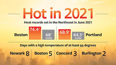
Boston; Portland and Caribou, Maine, shattered records for average June temperatures. That month, Boston was an average of 74.4 degrees (68 degrees, normal), while Portland averaged 68.9 degrees (64.3 degrees, normal) and Caribou – one of the region’s perennial cool spots – experienced 64.9 degrees (61.4, normal.)
On June 30, Newark (103 degrees) and Boston (100 degrees) logged their all-time hottest June temperatures.
Several cities set or tied records for the greatest number of June days with a high temperature of at least 95 degrees, including Newark (8), Boston (5), Concord, New Hampshire (3) and Burlington, Vermont (2). Concord saw its greatest number of June days (9) with a high of at least 90 degrees.
Seven sites recorded their warmest-ever minimum June temperatures. June 27: Caribou, 69 degrees; Rochester 75 and Syracuse 78. June 28: Dulles Airport, Chantilly, Virginia, 74. June 29: Concord 74, Harrisburg 79 and Portland 75.
The wet July seemed to be precursor for a soaking August and September. The NRCC saw that 26 of 35 major climate sites in the region had a wetter than normal month. Four places – Concord at 13.04 inches (3.62 inches, normal); Worcester, Massachusetts at 13.85 inches (3.93 inches, normal; Binghamton, New York at 9.82 inches (3.8 inches, normal; and Huntington, West Virginia at 9.50 inches (5.08 inches, normal) – endured their wettest July on record.
Heat did not abate: The month of August ranked as the warmest on record for Caribou, Syracuse and Buffalo, and ranked among the 10 warmest on record for 25 regional locations.
Tropical Storm Fred rumbled through the region on Aug. 18-20, spawning 10 tornadoes, seven of which touched down in Pennsylvania. Fred’s remnants, together with a frontal system, produced heavy rain in central and western New York, northern Connecticut, and central Pennsylvania – which endured between 4 and 8 inches of rain.
On Aug. 22, Tropical Storm Henri made landfall near Westerly, Rhode Island. That storm dropped 5 to 9 inches of rain in parts of southeast New York, New Jersey and eastern Pennsylvania, according to the NRCC. In fact, Central Park in New York City recorded its wettest two-day period on record for August, picking up 7.12 inches of rain from Aug. 21 to 22.
Tropical Depression Ida – on Sept. 1 – brought a catastrophic volume of rain (8- to 11-inch rainfall totals) to the region, from eastern Pennsylvania to northern and central New Jersey, through the New York City metro area and into southern New England, which saw rainfall totals of more than 6 inches. In fact, Newark got 8.41 inches of rain, making it the city’s all-time wettest day on record and leading September 2021 to become the site’s wettest September on record with 10.50 inches (3.82, normal).
Newark recorded its all-time wettest hour on record, catching 3.24 inches of rain between 8 and 9 p.m. The site’s two-hour and six-hour total of 7.88 inches all qualified as 500-year storm events, meaning they have a 0.2% chance of happening in any given year, according to the NRCC.
Similarly, on Sept. 1, Central Park endured its wettest-ever hour on record with 3.15 inches of rain from 9 to 10 p.m. Central Park’s two-hour rainfall of 4.65 inches qualified as a 500-year storm event.
The NRCC is part of CALS, and it is funded by the National Oceanic and Atmospheric Administration. DeGaetano is a faculty fellow at the Cornell Atkinson Center for Sustainability, and he serves on the state’s Climate Impacts Assessment project steering committee.
Source/Credit: Cornell University / Blaine Friedlander
en011322_04


.jpg)